National Park Service News Release
FOR IMMEDIATE RELEASE: DATE: July 16, 2013
CONTACT: Cyndy M. Holda, Public Affairs Specialist, 252-475-9034
Ramp 43 and 44 Reopen to ORV Access
Soundside Access near Hatteras Inlet Closes
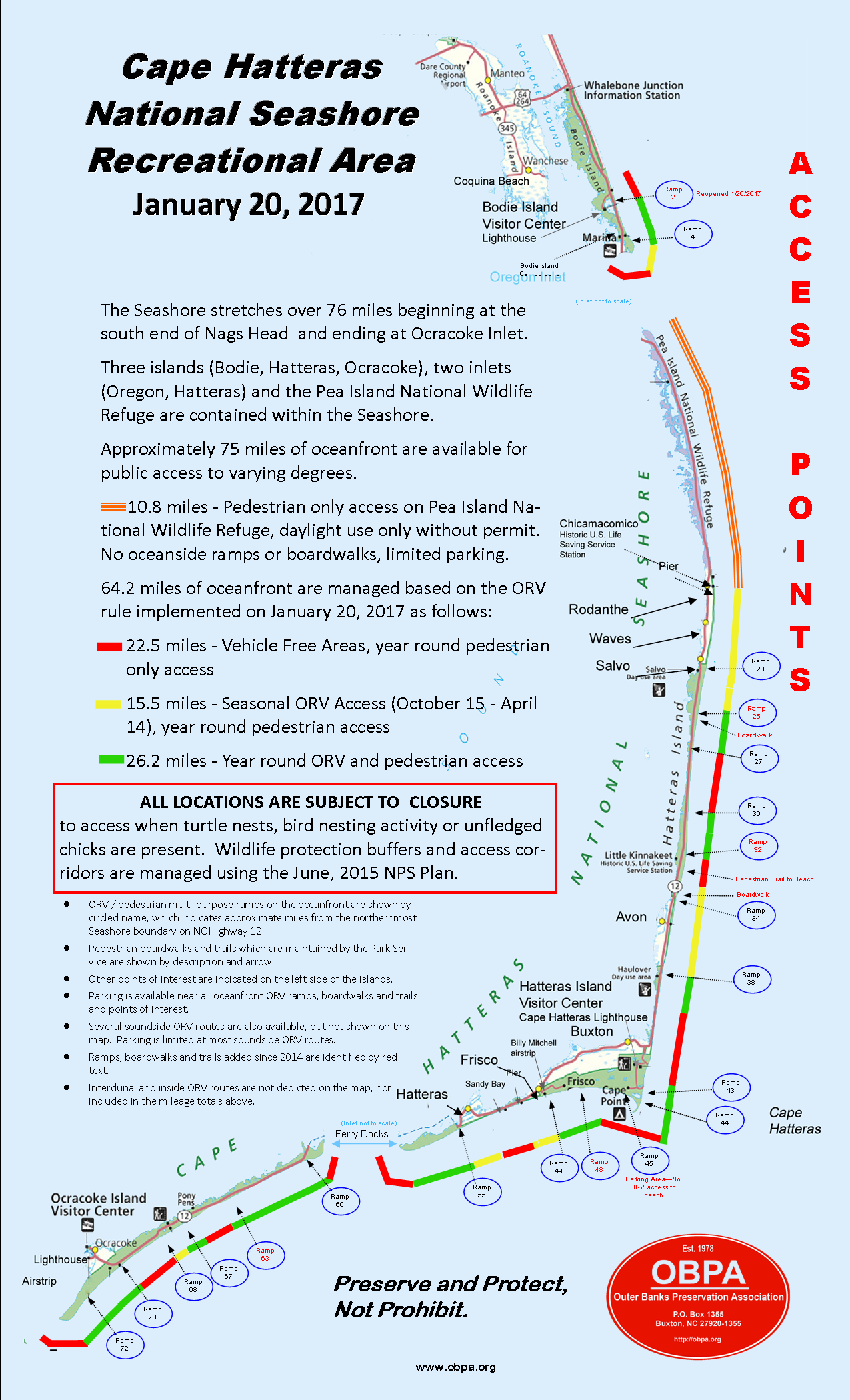
Superintendent Barclay Trimble announced today the reopening of two popular off-road vehicle ramps in the Buxton area of Cape Hatteras National Seashore. Ramps 43 and 44 reopened to off-road vehicle (ORV) use on the morning of July 16, 2013 as the shorebird nesting season comes to a close in this section of the Seashore. There is ORV access from Ramp 43 north for approximately .04 of a mile and from Ramp 44 south for approximately .05 of a mile. There is no thru ORV access from Ramp 43 to Ramp 44 due to an existing prenesting protection area. Pedestrians can bypass the prenesting closure in the ocean surf zone of the shoreline. As a reminder, the nighttime restriction on beach driving is still in effect on all National Seashore beaches from 9:00 p.m. to 7:00 a.m.
In addition, and due to unsafe shoreline erosion conditions on the soundside of Hatteras Inlet, the “Bone Road” is closed for ORV use. The shoreline is very narrow with a 2-3 foot escarpment and does not safely permit ORV access; pedestrian access is permitted.
For up-to-date information on currently open or closed areas, check the Cape Hatteras National Seashore’s Google Earth maps at:
http://www.nps.gov/caha/planyourvisit/off-road-vehicle-use.htm
For more information, please call the Public Affairs Office at 252-475-9034 or 252-473-2111.
-NPS-
Cape Hatteras National Seashore
Resource Management Field Summary
July 9, 2013
*All numbers are preliminary and the data will
be reviewed before they are finalized.
Piping Plover Summary:
|
Location |
# Nests to Date |
# Active Nests |
# Active Broods |
# Fledglings |
|
Bodie Island |
0 |
0 |
0 |
0 |
|
Cape Point |
7 |
0 |
2 |
2 |
|
South Beach |
0 |
0 |
0 |
0 |
|
North Ocracoke |
0 |
0 |
0 |
0 |
|
South Ocracoke |
2 |
0 |
0 |
0 |
|
Total |
9 |
0 |
1 |
3 |
Wilson’s Plover Summary:
|
Location |
# Nests to Date |
# Active Nests |
# Active Broods |
# Fledglings |
|
Bodie Island |
0 |
0 |
0 |
0 |
|
Cape Point |
0 |
0 |
0 |
0 |
|
South Beach |
0 |
0 |
0 |
0 |
|
North Ocracoke |
1 |
0 |
1 |
0 |
|
South Ocracoke |
3 |
0 |
1 |
1 |
|
Total |
4 |
0 |
2 |
1 |
American Oystercatcher Summary:
|
Location |
# Pairs |
# Nests to Date |
# Active Nests |
# Active Broods |
# Fledglings |
|
Bodie Island |
2 |
4 |
0 |
1 |
0 |
|
Green Island |
3 |
6 |
0 |
2 |
0 |
|
Hatteras Island |
14 |
23 |
1 |
1 |
1 |
|
Ocracoke Island |
9 |
9 |
0 |
2 |
7 |
|
Total |
28 |
42 |
1 |
6 |
8 |
Colonial Waterbirds:
|
Location |
# Active Colonies to Date |
# Currently Active Colonies |
|
Bodie Island |
2 |
2 |
|
Green Island |
1 |
1 |
|
Hatteras Island |
13 |
8 |
|
Ocracoke Island |
3 |
3 |
|
Total |
19 |
14 |
Sea Turtles:
|
Location |
# Nests |
# False Crawls |
|
Bodie Island |
5 |
4 |
|
Hatteras Island |
81 |
92 |
|
Ocracoke Island |
29 |
33 |
|
Total |
115 |
129 |
Summary Mileage Table
- As of 7/10/2013
Bodie Island Area 5.74
Open to ORVs 2.19
Closed for Resource Protection 1.06
Open to Pedestrians 2.50
Hatteras Island 40.46
Open to ORVs 8.12
Closed for Resource Protection 7.82
Open to Pedestrians 24.76
Ocracoke Island 17.87
Open to ORVs 7.64
Closed for Resource Protection 4.37
Open to Pedestrians 5.85
Total Ocean & Inlet Shoreline 64.07
Total Miles Open to ORVs 17.95
Total Miles Closed for Resource 13.25
Total Miles Open to Pedestrians (Only) 32.88
Total Miles Open to Pedestrians (Includes ORV areas) 50.82
Ramp by Ramp open access for ORV traffic (Updated 07-10-2012)
(Bodie Island Total-2.2 miles open)
Ramp 4 NORTH 1.85 mi. OPEN
Ramp 4 South .35 mi. open
(Hatteras Total – 7.75 miles open)
Ramp 23 CLOSED Til 11-1-12
Ramp 27North .35 Miles CUL-DA-SAC open Ramp 27 to Ramp 30 CLOSED
Ramp 30 South 2.1 miles open
Ramp 34 CLOSED
Ramp 38 South 0.9 miles open
Ramp 43 CLOSED
Ramp 44 to Cape Point CLOSED
Ramp 45 CLOSED
Ramp 49 East 1.7 miles open
Ramp 49 West to Frisco Village Line 1.1 miles open
Ramp 55 West beach shoreline 1.6 miles open
Ramp 55 Interdunal (Pole) Road with small
sound-side access behind Coast Guard Base 2.3 miles open but
Spur Road and Cable Crossing this is not
beach access
Ocracoke Total – 7.5 miles open
Ramp 59 North CLOSED
Ramp 59 South 2.4 miles open
Ramp 67 North 1.0 miles open
Ramp 67 South 0.7 miles open
Ramp 68 CLOSED\
Ramp 70 North 0.4 miles
Ramp 70 TO RAMP 72 1.7 miles open
Ramp 72 South 1.3 miles open
These are rough numbers only. Some of these miles are too narrow
to drive safely.
TOTAL ORV ACCESS CAPE HATTERAS NATIONAL SEASHORE
17.45 MILES OPEN
Per NPS Google Map!!!!!!!!!

