|
National Park Service U.S. Department of the Interior |
Outer Banks Group: · Cape Hatteras National Seashore · Fort Raleigh National Historic Site · Wright Brothers National Memorial |
1401 National Park Road 252-473-2111 phone |
National Park Service News Release
FOR IMMEDIATE RELEASE: DATE: May 7, 2010
CONTACT: 252-473-2111
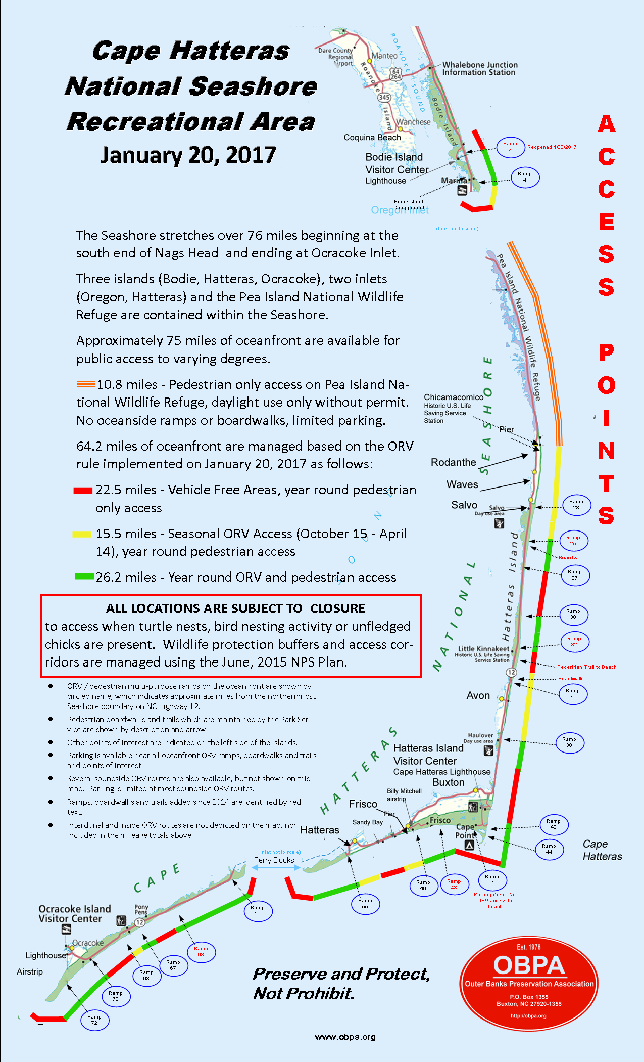
Access Update for Ramp 23 South of Salvo
Superintendent Mike Murray announced today the temporary closure of off-road vehicle Ramp 23, which is located approximately 0.3 of a mile south of Salvo on Hatteras Island. The ramp is temporarily closed for shorebird breeding activity, as prescribed under the terms of the court ordered consent decree.
The ramp is closed to both pedestrian and off-road vehicle (ORV) access and there is no through ORV access between Ramp 23 and Ramp 27. The Ramp 23 parking lot remains open for public use and from the parking lot pedestrians can access the ocean shoreline south of the marked protection area. Ramp 27 remains open for ORV use.
Temporary resource protection areas are necessary to protect threatened or endangered species and species of concern including piping plovers, American oystercatchers, colonial waterbirds (3 species of terns and black skimmers), and sea turtles. Posted areas are closed to vehicles, pedestrians, and pets. Entering a posted resource protection area or destruction of closure signs, fencing or other government property are federal criminal violations, subject to a fine of up to $5,000.00 and imprisonment of up to six months.
For up-to-date information on currently open or closed areas, check the Cape Hatteras National Seashore’s Google Earth maps at: http://www.nps.gov/caha/planyourvisit/googleearthmap.htm
For more information, call 252-473-2111 ext. 148.
-NPS-
Ramp by Ramp open access for ORV traffic (Updated 4-29-2010)
(Bodie Island Total-4.3 miles open)
Ramp 2 - (Seasonal Closure) CLOSED
Ramp 2 to Ramp 4 (Coquina Bch Area) 2.4 miles open
Ramp 4 – South Oregon Inlet (Bodie Island Spit) 1.9 miles open
(Hatteras Total – 25.2 miles open)
Rodanthe-Waves – Salvo Villages to Ramp 23 5.3 miles open
Ramp 23 South – Ramp 27 4.3 miles open
Ramp 27 South 0.1 miles open
Ramp 30 North 0.7 miles open
Ramp 30 South 1.3 miles open
Ramp 34 North 2.5 miles open
Ramp34 South to Ramp 38 3.9 miles open
Ramp 38 South 0.8 miles open
Ramp 43 North 0.4 miles open
Ramp 43-South 0.1 miles open
Ramp 44 to Cape Point Tip 1.0 miles open
Cape Point Tip – West on South Beach 0.2 miles open
Ramp 45 Cul-da-sac 0.1 miles open
Ramp 49 East 2.1 miles open
Ramp 49 West to Frisco Village Line 1.2 miles open
Ramp 55 East 0.1 miles open
Ramp 55 West beach shoreline 1.1 miles open
Ramp 55 Interdunal (Pole) Road with small sound-side access behind Coast Guard Base
(Ocracoke Total – 7.6 miles open)
Ramp 59 North 0.2 miles open
Ramp 59 South 0.9 miles open
Ramp 67 North 0.7 miles open
Ramp 67 South 0.8 miles open
Ramp 70 North 2.8 miles open
Ramp 70 - Ramp 72 1.8 miles open
Ramp 72 South 0.4 miles open
These are rough numbers only. Some of these miles are too narrow to drive safely.

